


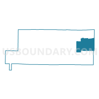
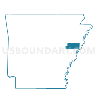
HETH PCT 6, St. Francis County, Arkansas
About
Outline

Summary
| Unique Area Identifier | 527979 |
| Name | HETH PCT 6 |
| County | St. Francis County |
| State | Arkansas |
| Area (square miles) | 46.65 |
| Land Area (square miles) | 46.63 |
| Water Area (square miles) | 0.01 |
| % of Land Area | 99.97 |
| % of Water Area | 0.03 |
| Latitude of the Internal Point | 35.03934920 |
| Longtitude of the Internal Point | -90.47656480 |
Maps

Graphs
Select a template below for downloading or customizing gragh for HETH PCT 6, St. Francis County, Arkansas


Neighbors
Neighoring Voting District (by Name) Neighboring Voting District on the Map
- BLACKFISH PCT 7, St. Francis County, AR
- BLACKFISH PCT 7, St. Francis County, AR
- Bob Ward, Crittenden County, AR
- GARLAND PCT 4, St. Francis County, AR
- RAWLINSON PCT 5, St. Francis County, AR
Top 10 Neighboring County Subdivision (by Population) Neighboring County Subdivision on the Map
- Garland township, St. Francis County, AR (1,710)
- Bob Ward township, Crittenden County, AR (982)
- Griggs township, St. Francis County, AR (746)
- Heth township, St. Francis County, AR (576)
- Black Fish township, St. Francis County, AR (111)
Top 10 Neighboring Unified School District (by Population) Neighboring Unified School District on the Map
- West Memphis School District, AR (25,528)
- Forrest City School District, AR (23,630)
- Hughes School District, AR (3,154)